
QGIS
3.0
Size: 397.19 MB
Downloads: 2431
Platform: Windows (All Versions)

QGIS places everything you need at your disposal, for viewing, editing and analyzing geospatial data. It is a free alternative to expensive geographic information system (GIS) software applications. Developed with the Qt toolkit and C++, this interesting piece of software really has a lot to offer. Fulls support for both vector and raster data, flexible customization options and a highly responsive user interface are just a few examples.
QGIS is distributed as a free and open source application and it is available for various operating systems, including Windows, Linux and Mac OS X. The installation process may take a bit longer than a minute and it will get interrupted, because the setup wizard will ask you if you also want certain components installed, but you won't have to make any complicated settings along the way.
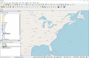
The software places a broad range of tools at your disposal, which is why its user interface may seem a bit crowded. It features a blank canvas and a large number of options all around it, on several panes, which can be moved to different locations by simply clicking and dragging them. Though you may need some time to familiarize yourself with the interface and its controls, you will find that QGIS can meet all your demands.
You can navigate through your local folders in a tree structure, directly on the software's interface and load the data you need at a moment's notice. QGIS lets you import raster images and you can also create vector layers and work with points, lines or polygons. What's more, the software supports numerous raster and vector formats and it lets you attach custom attributes to each layer, so you can specify any kind of details to each of your shapes.
Instead of being limited to simple layers, QGIS lets you create shape files, coverages, geo-databases and other layer types, which can be set to different geometry types, like lines, points, polygons and so on. Also, each layer can be saved separately in local folders.
There are numerous features to discover in QGIS, including the possibility of integrating the software with third party GIS packages. Plug-ins, written in Python and C++, can be installed on the fly, with the aid of the program's built-in plug-ins manager.
Regardless of what you need to do, when it comes to working with geospatial data, QGIS has everything you need, conveniently placed in one package.
Pros
The software supports numerous raster and vector formats. It lets you work with various layer types, attach custom attributes and save them separately. Also, QGIS provides support for numerous plug-ins.
Cons
You may need some time to get used to the interface and its controls, but it shouldn't be a problem if you have experience with geospatial data.
QGIS
3.0
Download
QGIS Awards

QGIS Editor’s Review Rating
QGIS has been reviewed by Frederick Barton on 28 Mar 2018. Based on the user interface, features and complexity, Findmysoft has rated QGIS 5 out of 5 stars, naming it Essential